Dr Christina Magill of Risk Frontiers, Macquarie University, looks at the potential catastrophe of a repeat volcanic eruption with the magnitude of the 1707 Hoei eruption from Mount Fuji. Because large eruptions have been infrequent, not enough attention has been paid to them and their potential devastating consequences.
It is only by chance that a major city such as Tokyo, Jakarta, Manila or Singapore has not been affected by a significant volcanic eruption in recent times. Long return periods and uncertainty in respect to magnitude, duration, style and hazard types, has led to the potentially devastating consequences of eruptions being largely ignored.
This was also true of tsunami until recent events reminded us of the inevitability of high impact events. In a similar vein, we should not ignore volcanic risks and prepare for potentially severe and widespread impacts within the Asia-Pacific region.
Probability of eruption in the Asia-Pacific region
Volcanic eruptions have traditionally been classified by a Volcanic Explosivity Index (VEI), a logarithmic semi-quantitative scale incorporating variables such as eruption volume, plume height and duration (Newhall and Self, 1982).
While a VEI 0 or 1 eruption may involve only a gentle effusion of lava, eruptions greater than VEI 2 become progressively more voluminous and explosive. Greater than VEI 5, the volume of erupted material may cause large scale disruption and damage while VEI 7 or 8 eruptions are likely to be truly cataclysmic.
Past eruptions are described in historical records and identified through geological studies, where techniques such as radiocarbon, Potassium-Argon and dendrochronology are used to date deposits.
The probability of eruptions being identified decreases the further back in time we go; this is especially difficult in the case of smaller eruptions. Therefore, before calculating the likelihood of future events we must first consider the completeness of the eruption record for various eruption magnitudes.
Although individual volcanoes, or those sharing the same magma system, may display eruption clustering or other time-dependent fluctuations in activity, at the regional level it is acceptable to assume activity fits a Poissonian distribution.
Mead and Magill (2014) calculated the periods for which data is assumed to be complete for the Smithsonian Volcanoes of the World catalogue (http://volcano.si.edu/) at both country level and for defined regions.
Considering only the Asia-Pacific region (the Philippines, Indonesia, Japan, Vanuatu, Papua New Guinea, New Zealand to Fiji), we can calculate average recurrence intervals for each VEI category (Figure 1).
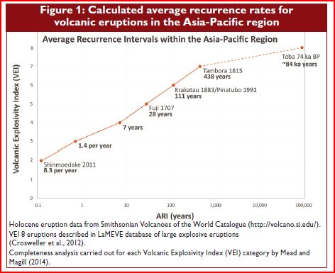
While eruptions greater than or equal to VEI 2 may occur on average more frequently than eight times a year, those like Pinatubo in 1991 or Krakatau in 1883 occur approximately every 110 years.
Two hundred years ago, Tambora produced the largest eruption in recorded history with ash 1m thick falling 75 km from the volcano; 11-12,000 people were killed directly, while another ~60,000 died from starvation and disease due to crop failure (Oppenheimer, 2003). On average an eruption of this magnitude has occurred every ~450 years and this scenario therefore presents the most credible extreme threat for which we should prepare.
Impacts
A volcanic eruption may be over in a matter of hours or continue for many years or decades.
Intense localised hazards such as pyroclastic flows and lahars may decimate areas near to source and along the volcano’s drainage networks. In extreme cases, a tsunami may originate from the collapse of edifices or the eruption of material into the ocean or a lake.
In large eruptions, climate may be affected for several seasons primarily due to the injection of ash particles into the troposphere and stratosphere, decreasing the amount of sun-light reaching the earth’s surface.
The most common wide-reaching hazard is that of tephra (volcanic ash) fall. Accumulation of tephra may lead to building collapse: 10 cm of ash can weigh over 150 kg per square metre, with rain further increasing this weight. Smaller thicknesses may damage gutters, carports, air conditioning units and furnishings (Blong 1981; Magill and Blong, 2006).
Agriculture is particularly vulnerable to the physical and chemical effects of tephra fall that may directly impact crops, soil, animal health, farm infrastructure and machinery (Wilson et al., 2011; Magill et al., 2013). Thicknesses of several centimetres can smother crops, change soil properties and damage greenhouses. Even thin dustings of tephra can adhere to plants, blocking photosynthesis and causing acid damage (Figure 2).

Road markings are obscured by less than 1 mm of tephra requiring roads to be cleaned; falling and remobilised ash reduces visibility raising traffic safety concerns. Likewise, trace amounts of ash in the atmosphere are enough to restrict flight paths and close airports. Eyes and throats can become irritated and respiratory health is adversely affected.
In the case of another catastrophic eruption, the largest impacts may be to critical utility and infrastructure networks. Huge economic losses are expected from disruptions to business, manufacturing and global supply chains.
Another large eruption today
Although it is impossible to predict the location or nature of the next major eruption, it is interesting to consider the consequences of past events assuming they were to reoccur today given modern societal conditions.
With this in mind, we analysed the areas exposed to tephra hazards for four previous eruptions in the Asia-Pacific region (Figure 3). Calculated areas and populations (Table 1) are based solely on environmental conditions at the time of each eruption. The same eruption may have vastly different consequences if wind conditions varied or rain was to increase the weight of ash.

In terms of the volume of erupted material, these four eruptions vary by almost four orders of magnitude; however, in terms of impacts, our analysis highlights the critical importance of eruption location.
A repeat of the 1707 Fuji eruption would affect an urban area larger than that impacted by a repeat of the 1815 Tambora eruption. A recurrence of the 1991 Pinatubo eruption would affect a large agricultural land area but a relatively smaller population. An eruption the size of Toba approximately 74,000 years ago would severely impact most of the land area of Indonesia, Malaysia, Singapore, Thailand, Laos, Cambodia, Vietnam, Myanmar, Bangladesh, India and Sri Lanka.
Tephra would travel as far as Africa and have severe global consequences.
Thankfully only three eruptions of this magnitude (VEI 8) have occurred within the Asia-Pacific region over the past 254 ka (kilo-annum or thousands years). The remaining two were from the Taupo Volcanic Zone, New Zealand.
A much more pressing worry is a repeat of an eruption similar to the 1815 Tambora eruption, Indonesia. An event of this magnitude has a return period of less than 500 years; tens of millions of people would be affected if such an eruption were to take place within Indonesia, the Philippines or Japan. Unprecedented losses, casualties and business disruptions would result if the eruption was to occur close to a large population centre.
|
KazanRisk – Volcanic hazard and loss model for Tokyo
A repeat of the 1707 Hoei eruption from Mount Fuji would see approximately 30 million people impacted by more than 10 mm of tephra. This includes almost the entire area of Kanagawa and Chiba prefectures, the highly populated eastern area of Tokyo prefecture and parts of Shizuoka, Yamanashi and Saitama.
Home to Japan’s national government, this area is also a major national and international hub for business, manufacturing and transport. A similar eruption today, would disrupt these sectors and severely damage buildings and infrastructure. The clean-up requirements would be immense with assistance and resources having to be sourced from outside the affected area.
Detailed simulations have been carried out to replicate this event and calibrate tephra dispersal modelling (Magill et al., 2014). However, the next eruption from Fuji Volcano is likely to be very different from the 1707 event and, when assessing risk, we must consider all potential magnitude, style and weather possibilities. Although the most visible, Fuji is not the only threat to Tokyo; the city may be affected by a large number of volcanoes, with those immediately to the west posing the greatest hazard.
KazanRisk is a fully probabilistic volcanic loss model and calculates gross and insured losses to buildings – structural damage, non-structural damage and property clean-up – as well as the costs associated with the clean-up of roads and public areas, and loss of agri-cultural productivity due to crop damage, effects to livestock and damage to farm equip-ment.
KazanRisk contains a catalogue of 60,000 tephra fall events from six volcanic centres – Fuji, Asama, Hakone, Haruna, Kusatsu-Shirane and Kita-Yatsugatake. Simulations were car-ried out using the Tephra2 dispersal model (www.cas.usf.edu/~cconnor/vg@usf/tephra.html) with mass loading calculated over a 1 km grid. Losses are calculated at the same resolution with results presented as kml maps (Figure 4), Exceedance Probability curves and summary statistics.

KazanRisk is a first step in calculating volcanic losses within the Asia-Pacific region, focussing on one of the most exposed urban areas. Future work will incorporate regional level hazard modelling (e.g. Jenkins et al., 2012), detailed investigation of the time dependent behaviour of individual volcanoes, and local vulnerability studies.
Modelling will include locally devastating hazards such as lahars and pyroclastic flows and will begin to consider activity of extended duration. As our research knowledge improves, we will move further towards being able to quantify risk so that we can begin to plan for and mitigate against the consequences of potentially devastating volcanic eruptions.
|
Dr Christina Magill is Senior Risk Scientist at Risk Frontiers, Macquarie University.
Full reference list available. Please email christina.magill@mq.edu.au.